Geospatial analysis-based approach for assessing urban forests under the influence of different human settlement extents in Ibadan city, Nigeria
DOI:
https://doi.org/10.15835/nsb12410808Keywords:
GIS; human settlement; remote sensing; remotely sensed data; urban forestsAbstract
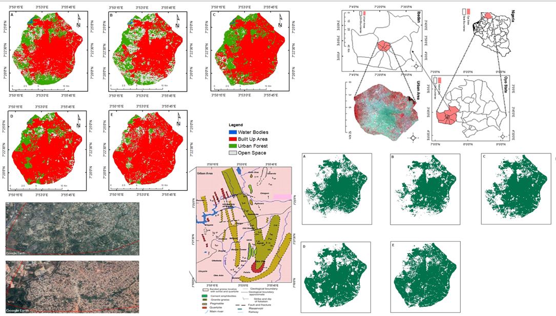
Urban forests are an essential component of urban areas as they provide many environmental and social services that contribute to the quality of life in cities. Urban forests in most cities of Nigeria are gradually becoming bitty as a result of urbanization activities, thereby posing adverse effects. In this study, we assessed the changes in the urban forests cover under the influence of different human settlement (HS) extents across the urban area of Ibadan city using remotely sensed data. The pattern of change(s) in the urban forests cover over 20 years were examined by analysing and manipulating Landsat and Sentinel-2 datasets using Google Earth Engine, ArcGIS 10.1, and Erdas 2014 software. The extents of human settlement (for the year 2000, 2005, 2010, 2015, and 2020) were extracted (from Landsat datasets), analysed, and mapped to evaluate the status of the urban forests cover under different human settlement extents. The result reveals a substantial land cover changes within the urban area of Ibadan. The urban forest cover decreased from 24.14% to 7.99%. Also, there is a significant decrease in the urban forests cover as a result of a substantial increase in human settlement extent (102,806 to 122,572 pixels). The study provides an opportunity to map the status of urban forest cover and extents of HS in a developing city using remotely sensed data and applications of GIS tools.
Metrics
References
Adelusi HM, Agboola OD, Oni PI (2002). Urbanisation: implications for forest resources depletion and environmental degradation in Nigerian case study Ibadan city. In Forestry and challenges of sustainable livelihood. Proceedings of the 28th Annual Conference of the Forestry Association of Nigeria, Akure, Ondo State, Nigeria, 4-8 November, 2002 Forestry Association of Nigeria, pp 69-79.
Agbola BS, Ajayi O, Taiwo OJ, Wahab BW (2012). The August 2011 flood in Ibadan, Nigeria: Anthropogenic causes and consequences. International Journal of Disaster Risk Science 3(4):207-217. https://doi.org/10.1007/s13753-012-0021-3
Akingbogun AA, Kosoko OS, Aborisade DK (2012). Remote sensing and GIS application for forest reserve degradation prediction and monitoring. In: First FIG young surveyors conference knowing to create the future. Rome pp 4-5.
Amanambu AC (2015). Geogenic contamination: Hydrogeochemical processes and relationships in shallow aquifers of Ibadan, South-West Nigeria. Bulletin of Geography. Physical Geography Series 9(1):5-20. https://doi.org/10.1515/bgeo-2015-0011
Zamzami SZ, Mansor S (2012). The use of multi-sensor for illegal human settlement detection. Asian Journal of Environment-Behaviour Studies 3(10):71-80. https://doi.org/10.21834/aje-bs.v3i7.270
Banai R, DePriest T (2010). Urban sprawl: Definitions, data, methods of measurement, and environmental consequences. Education 7.
Booth TH (1990). Mapping regions climatically suitable for particular tree species at the global scale. Forest Ecology and Management 36:47-60. https://doi.org/10.1016/0378-1127(90)90063-H
Burchell RW, Shad NA (1999). The incidence of sprawl in the United States. TCRP Report H 10, National Academy Press, Washington, D.C., The evolution of the sprawl debate in the United States. West. Northwest 5(2):137-160.
Booth TH, Stein JA, Nix HA, Hutchinson MF (1989). Mapping regions climatically suitable for particular species: an example using Africa. Forest Ecology and Management 28(1):19-31. https://doi.org/10.1016/0378-1127(89)90071-6
Chen R, Guinness RE (2014). Geospatial computing in mobile devices. Artech House pp 228.
Clark JR, Matheny NP, Cross G, Wade V (1997). A model of urban forestry sustainability. Journal of Arboriculture 23(1):17-30.
Gann SB (2003). A methodology for inventorying stored carbon in an urban forest. An unpublished paper submitted to the faculty of Virginia Polytechnic Institute and State University in partial fulfilment of the requirements of the degree of M.Sc Forestry.
Goodwin NR, Collett LJ, Denham RJ, Flood N, Tindall D (2013). Cloud and loud shadow screening across Queensland, Australia: An automated method for Landsat TM/ETM+ time series. Remote Sensing of Environment 134:50-65. https://doi.org/10.1016/j.rse.2013.02.019
Gorelick N, Hancher M, Dixon M, Ilyushchenko S, Thau D, Moore R (2017). Google Earth Engine: Planetary-scale geospatial analysis for everyone. Remote Sensing of Environment 202:18-27. http://doi.org/10.1016/j.rse.2017.06.031
Hasse J, Lathrop GR (2003). A housing-unit-level approach to characterizing residential sprawl. Photogrammetric Engineering and Remote Sensing 69(9):1021-1030. https://doi.org/10.14358/PERS.69.9.1021
Housman I, Tanpipat V, Biswas T, Clark A, Stephen P, Maus P, Megown K (2015). Monitoring forest change in southeast Asia: case studies for USAID lowering emissions in Asia’s forests (No. RSAC-10108-RPT1). Salt Lake City, UT: U.S. Department of Agriculture, Forest Service, Remote Sensing Applications Center pp 16.
Huang C, Thomas N, Goward SN, Masek JG, Zhu Z, Townshend JRG, Vogelmann JE (2010). Automated masking of cloud and cloud shadow for forest change analysis using Landsat images. International Journal of Remote Sensing 31(20):5449-5464. https://doi.org/10.1080/01431160903369642
bin Ibrahim AL, Sarvestani MS (2009). Urban sprawl pattern recognition using remote sensing and GIS –Case study Shiraz city, Iran. Joint Urban Remote Sensing Event, pp 1-5. http://dx.doi.org/10.1109/URS.2009.5137528
Jain M (2008). GIS and remote sensing applications to study urban sprawl of Udaipur, India. Research Scholar, Mohan LalSukhadia University, Udaipur, Raj., India.
Klemas VV (2001). Remote sensing of landscape level coastal environmental indicators Environmental Management 27:47-57. https://doi.org/10.1007/s002670010133
Kuchelmeister G (2000). Contributions and management of urban forestry in an increasingly urbanized world. Trees for the urban millennium: urban forestry update. Unasylva 200(51):49-55.
Kumar MS, Singh H, Pandey R, Singh MP, Ravindranath NH, Kalra N (2019). Assessing vulnerability of forest ecosystem in the Indian Western Himalayan region using trends of net primary productivity. Biodiversity and Conservation 28:2163-2182. https://doi.org/10.1007/s10531-018-1663-2
Larinde SL (2010). Practical issues in urban forest establishment and management. In: Ijeoma HM, Aiyeloja AA (Eds). Practical issues in forestry and wildlife resources management published by green canopy consultants. Choba, Port Harcourt pp 241-259.
Feng L (2009). Applying remote sensing and GIS on monitoring and measuring urban sprawl- a case study of China. Revista Internacional Sostenibilidad, Tecnología y Humanismo (4):47-56.
Lunetta P, Smith GS, Penttila A, Sajantila A (2004). Unintentional drowning in Finland 1970-2000: a population-based study. International Journal of Epidemiology 33:1053-1063. https://doi.org/10.1093/ije/dyh194
Masek JG, Lindsay FE, Goward SN (2000). Dynamics of urban growth in the Washington DC metropolitan area, 1973-1996, from Landsat observations. International Journal of Remote Sensing 21(18:)3473-3486. https://doi.org/10.1080/014311600750037507
McPherson Gregory, Simpson JR (2001). Effects of California’s urban forests on energy use and potential savings from large-scale tree plantings. Center for Urban Forest Research, Davis, CA. http://www.fs.fed.us
McPherson EG, Rowntree RA (2016). Energy conservation potential of urban tree planting. Journal of Arboriculture 19(6):321-331.
Mohd Noor N, Alias A, Mazlan H, Zainora MA (2012). Managing urban land in developing countries using GIS and remote sensing: towards resilient cities. Department of Urban and Regional Planning, IIUM, Gombak, Malaysia.
Nasser HE, Overberg P (2001). What you don’t know about sprawl. US Today 22:6-9.
Noor NM, Rosni NA (2013). Determination of spatial factors in measuring urban sprawl in Kuantan using remote sensing and GIS. Procedia - Social and Behavioral Sciences 85:502-512. https://doi.org/10.1016/j.sbspro.2013.08.379
Nowak DJ, Crane DE, Stevens JC (2007). Air pollution removal by urban trees and shrubs in the United States. Urban Forestry & Urban Greening 4:115-123. https://doi.org/10.1016/j.ufug.2006.01.007
Nowak DJ, Noble MH, Sisinni SM, Dwyer JF (2001). People and trees: assessing the US urban forest resource. Journal of Forestry 99:37-42. https://doi.org/10.1093/jof/99.3.37
Olokeogun OS, Kumar M (2020). An indicator-based approach for assessing the vulnerability of riparian ecosystem under the influence of urbanization in the Indian Himalayan city, Dehradun. Ecological Indicators 119:106796. https://doi.org/10.1016/j.ecolind.2020.106796
Popoola L, Ajewole O (2001). Public perceptions of urban forests in Ibadan, Nigeria: implications for environmental conservation. Arboricultural Journal 25(1):122. https://doi.org/10.1080/03071375.2001.9747291
Savita PK, Sharma LK, Manoj K (2018). Forestry interventions for Ganga rejuvenation: a geospatial analysis for prioritizing sites. Indian Forester 144 (12):1127-1135.
Sierra Club (2001). Clearing the air with transit spending. http://www.sierraclub.org/sprawl/report01
Sudhira HS, Ramachandra TV, Jagadish KS (2003). Urban sprawl pattern recognition and modelling using GIS. Map India 28-31.
Tan KC, San Lim H, MatJafri MZ, Abdulla K (2010). Landsat data to evaluate urban expansion and determine land use/land cover changes in Penang Island, Malaysia. Environmental Earth Science 60:1509-1521. https://doi.org/10.1007/s12665-009-0286-z
Trianni G, Angiuli E, Lisini G, Gamba P (2014). Human settlements from Landsat data using google earth engine. International Geoscience and Remote Sensing Symposium (IGARSS) 1473-1476. https://doi.org/10.1109/IGARSS.2014.6946715
Tsai YH, Stow D, Chen HL, Lewison R, An L, Shi L (2018). Mapping vegetation and land use types in Fanjingshan national nature reserve using google earth engine. Remote Sensing 10(6):927. https://doi.org/10.3390/rs10060927
Weng Q (2002). Land use change analysis in the Zhujiang Delta of China using satellite remote sensing, GIS and stochastic modelling. Journal of Environmental Management 64(3):273-284.
Wolf KL (2005a). Trees in the small city retail business district: Comparing resident and visitor perceptions. Journal of Forestry 103(8):390-395.
Wolf KL (2005b). Business district streetscapes, trees and consumer response. Journal of Forestry 103(8):396-400.
Wolf KL (2008). City trees, nature and physical activity: A research review. Arborist News 17(1):22-24.
Wood JP (1999). Tree Inventories and GIS in urban forestry. Project report submitted to the Faculty of the Virginia Polytechnic Institute and State University in partial fulfilment of the requirements for the degree of Master in Forestry, Blacksburg, Virginia.
Yeh AGO, Xia L (2001). Measurement and Monitoring of urban sprawl in a rapidly growing region using entropy. Photogrammetric Engineering & Remote Sensing 67(1):83-90.
Zhu Z, Wang S, Woodcock CE (2015). Improvement and expansion of the Fmask algorithm: cloud, cloud shadow, and snow detection for Landsats 4-7, 8, and Sentinel 2 images. Remote Sensing of Environment 159:269-277. https://doi/org/10.1016/j.rse.2014.12.014
Downloads
Published
How to Cite
Issue
Section
License
Papers published in Notulae Scientia Biologicae are Open-Access, distributed under the terms and conditions of the Creative Commons Attribution License.
© Articles by the authors; licensee SMTCT, Cluj-Napoca, Romania. The journal allows the author(s) to hold the copyright/to retain publishing rights without restriction.
License:

![]()
Open Access Journal - the journal offers free, immediate, and unrestricted access to peer-reviewed research and scholarly work, due SMTCT supports to increase the visibility, accessibility and reputation of the researchers, regardless of geography and their budgets. Users are allowed to read, download, copy, distribute, print, search, or link to the full texts of the articles, or use them for any other lawful purpose, without asking prior permission from the publisher or the author.
![]()


.png)